8.1 ha ( 19.9 acres ) property near the old settlement of Moha on the Yalakom Road 31 km ( 19 miles ) northwest of the Municipality of Lillooet in the Province of British Columbia.
The property is located near the confluence of the Bridge and Yalakom Rivers in the Squamish-Lillooet Regional District. The zoning is Rural Resource 5 ( RR5 ) which permits, among others things, the building of 2 single family dwellings ( or 1 duplex ) and associated buildings. The property has 490 m ( 1/3 mile ) frontage on the Yalakom River and 410 m ( 1/4 mile ) frontage on the Yalakom Road.
The Moha area has year round sunshine and a mild winter climate. The property has views of the snow-capped Shulaps and Mission mountains, and of the Camelsfoot mountains. The property is 1.2 km ( 3/4 mile ) from Fred Antoine Provincial Park.
Lillooet is a 4 hours drive from the City of Vancouver, 2 hours from the City of Kamloops, and 2 hours from the Resort Municipality of Whistler.
Location of the property: ( 50° 52' 8.6" North and 122° 10' 17.0" West ) or ( 50.869048, -122.171381 )
Parcel Identifier ( PID ): 032-640-315
Year 2025 property taxes: $ 647
Elevation ( above sea level ) of the property: From 450 m to 550 m ( from 1475 feet to 1805 feet )
Stated measurements are approximate.
Image 1: Next to the Yalakom Road at the north end of the property viewing southeast towards the Mission mountains at 2440 m ( 8000 ft ).
Image 2: At the north end of the property viewing northwest up the Yalakom Valley.
Image 3: At the north end of the property viewing west towards the Shulaps mountains at 2560 m ( 8400 ft ).
Image 4: At the north end of the property viewing east towards to the Camelsfoot mountains.
Image 5: View of the bridge where the Lillooet-Pioneer Road ( also called the Bridge River Road or Highway 40 ) crosses the Yalakom River.
Image 6: At the junction of the Lillooet-Pioneer Road and the Yalakom Road.
Image 7: At the north end of the property viewing southeast towards the Mission mountains at 2440 m ( 8000 ft ).
Image 8: On the Yalakom Road at the south end of the property looking southwest in the direction of the southern property line.
Image 9: The property outlined in red colour on a satellite view.
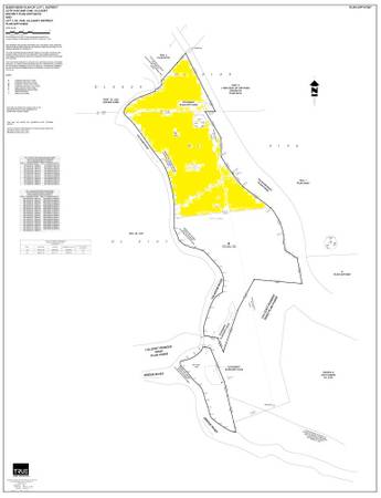
Image 10: The property marked in yellow colour on survey plan.
Information on Moha..............................................................http://en.wikipedia.org/wiki/Moha,_British_Columbia
Information on the Bridge River Valley..................................http://www.bridgerivervalley.ca/
Information on Lillooet...........................................................https://visitlillooet.ca/
Information on how to get to Lillooet....................................https://www.rome2rio.com/map/Vancouver-BC-Canada/Lillooet#r/Drive/s/0
Information on how to get to Moha........................................https://www.rome2rio.com/map/Lillooet/Moha-BC-Canada
Information on the Bridge River Valley and Moha.................http://bcadventure.com/murphys/gold/river.htm
Information on Fred Antoine Provincial Park.........................https://peakvisor.com/park/fred-antoine-provincial-park.html
Video of the area.....................................................................https://www.youtube.com/watch?v=uaq_rPap5OA
Satellite view of the property ( highlight text below, right click highlighted text, and choose “Go to - - -” ):